|
|
|
|
|

|
Black Fire, May 16, 2022 Photo: US Forest Service
|
Forest Service wildfire management policy run amok
From suppressing fires, to confining fires, to expanding fires,
to igniting fires
|
One of the most important roles of the US Forest Service is to contain wildfires. Firefighters can often help to prevent wildfires from becoming disastrous to the human environment — they can help to protect communities, along with homeowners’ own efforts to fireproof their properties. However, Forest Service wildfire management policy can also cause the destruction of communities, and result in excessive and overly-frequent burning of some of our most valuable natural resources such as old growth, sensitive species and their habitats, and watersheds.
Conservation scientists strongly support “managed wildfire for resource benefit,” which means allowing naturally ignited wildfires to burn when safe to do so. When this is done, fire lines are built to protect communities and other values that could be impacted by the wildfire. This helps to return the natural role of fire in our forests, because fires of all intensities have a role in forest ecology and can promote biodiversity. However, there is also a limit on how much fire is beneficial to forests – too much fire can occur too fast when fires are intentionally ignited.
An increasing trend in Forest Service wildfire management tactics has been to combine intentional burning (prescribed burning) with emergency fire suppression. During at least three fires in New Mexico in just a little over a year, the Forest Service has utilized aerial and ground firing operations to expand wildfires, and to implement intentional burns on landscapes that would not have burned otherwise. These are the Black Fire in the Gila and Aldo Leopold Wildernesses, the Pass Fire in the Gila National Forest and Gila Wilderness, and the Comanche Fire in the Carson National Forest.
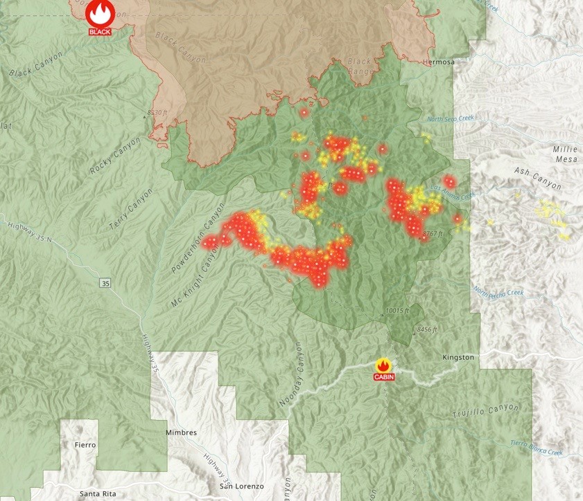
During the more than 325,000 acre Black Fire which ignited on May 13, 2022, it appears from ArcGIS aerial fire hot spot maps, that a very large area of the Aldo Leopold Wilderness was ignited by the USFS up to 10 miles to the south of the main fire with aerial firing operations – meaning dropping incendiary devices from helicopters or drones. See map below. This was clearly not any kind of large-scale back burn intended to contain the main fire, due to its distance from the main fire and its position relative to the wind direction.
This intentionally-ignited fire was herded to the north over several days until it joined the main fire. Then, on the Forest Service’s official fire perimeter map, both fires were suddenly joined together as one fire. There was no distinction made between the original fire which was not caused by USFS actions, and the sections of the fire to the south, amounting to a separate fire, that were directly ignited by the Forest Service. The agency had also expanded the main fire in other directions.
The intentional fire was only stopped by monsoon rains and by the intervention of a Sierra County Commissioner. Shouldn't there have been a public analysis process before burning most of the Aldo Leopold Wilderness?
The ignitions by the Forest Service, along with the main fire, created a boxing-in formation — fire burning in almost every direction, so that which was in the midst of the formation was surrounded by fire. During wildfires, and also during traditional prescribed burns, wildlife has the opportunity to escape because the fire is generally approaching from just one direction. In a boxing-in fire formation, wildlife can become trapped and either injured or incinerated. There are no opportunities before such on-the-spot firing operations to seriously consider habitats of sensitive and endangered species, or to protect old growth forest and other values.
During the Pass Fire, which was ignited by a lightning strike on May 18, 2023, a substantial section of pinon and juniper in the Beaver Points area was intentionally burned through aerial firing operations, and many other areas were burned in ground firing operations. The ground firing operations were described by the Forest Service as burn out operations, in order to contain the fire and to protect structures. However, those burn out operations seemed very excessive, and some observers considered them to also be intentional burning.
This fire was managed as a “confine and contain” operation – an operation intended to allow a wildfire to burn within a determined fire perimeter for the purpose of reducing the intensity of future fires and to ecologically benefit the landscape. At the beginning of the fire, the Forest Service published on the Gila National Forest Facebook page a map of an approximately 75,000 acre planned fire perimeter. The current fire perimeter almost exactly matches the originally published planned perimeter. See overlay of both maps here.
The Comanche Fire, which began on June 8, 2023, was essentially a prescribed burn, except that the USFS utilized a 20 acre lightning strike ignition as the “match” that lit the fire. They stated in a fire update on June 21 that they have completed, not contained, 1% of the operation at 99 acres, making it clear that they were burning intentionally. The designated “focus area", which appears to be a planned containment perimeter, was about 10,000 acres, broken into burn units. The intent was to expand a small lightning strike fire to at least 100 times its original size, utilizing both aerial and ground firing operations. The current size of this fire is 1,974 acres.
Such operations are now a substantial part of the work of firefighters across the West. Firefighters are essentially being used as intentional burn crews to implement fuels treatments, carried out with emergency fire suppression funding and no National Environmental Policy Act (NEPA) analysis. Some Forest Service personnel believe that we conservationists, by “holding their feet to the fire” to analyze intentional burn operations according to NEPA, are slowing down implementation of burn treatments. So, by expanding wildfires, or even starting new ones in the vicinity of wildfires, the Forest Service is able to greatly expand the implementation of burn treatments, and thereby meet agency quotas.
Any statistics or research about the extent of wildfire in recent years, in relation to climate change or presumed increases in wildfire activity, may be distorted by a substantial portion of total reported wildfire acreage being actually ignited by the Forest Service. This occurs while managing wildfires under full suppression, and in confine and control operations.
The Forest Service has put the concept of managed wildfire for resource benefit on steroids, often using wildfires as opportunities to ignite yet more fire, and to broadly burn landscapes. This is not managing wildfire, but essentially creating fires. They are now using our firefighters as agents to carry out this dangerous and possibly illegal policy that sometimes causes severe unintended consequences to forests and communities. That some burns are ultimately ecologically beneficial does not make it acceptable to carry out fuels treatments without a NEPA process.
Forest Service Chief Randy Moore’s “Wildfire letter of intent 2023” provided direction to agency staff regarding wildfire suppression, stating “We will also continue to use every tool available to reduce current and future wildfire impacts and create and maintain landscape resilience, including using natural ignitions at the right time and place in collaboration with tribes, communities, and partners.” While there is not necessarily a legal basis at this point even for this direction, Forest Service firing operations that expand wildfires cannot be considered to be using natural ignitions. Drones or helicopters dropping incendiary devices are clearly not natural ignitions. And firing operations miles from a wildfire cannot reasonably be considered back burns that are necessary to contain a wildfire.
We have no national wildfire policy that either allows, or places any limits on such operations, and emergency fire suppression funding is not allocated for implementing fuels treatments. The Forest Service has given themselves virtually a carte blanche to conduct intentional burns over a wide area nearby wildfires — all without NEPA analysis or any public involvement in the planning process.
A genuinely cohesive national wildfire policy is essential, analyzed through a comprehensive and open NEPA process. It is necessary to make sure fires are managed safely, and that values like old growth trees, wildlife and their habitat, water quality, and soils are protected. Public health in relation to the smoke generated during intentional burns must also be considered.
The purpose of NEPA is so agencies will “look before they leap,” and therefore avoid causing environmental disasters. We have had more than enough disasters occur, culminating with last year’s Hermits Peak/Calf Canyon Fire. If we allow the Forest Service to largely jettison NEPA and to freely implement fuels treatments under the guise of emergency fire suppression, we are giving up our primary means of protecting our forests and our communities, and it will affect other important conservation priorities. NEPA law acknowledges and supports our right to have a say on what occurs in our forests, and requires comprehensive analysis of the impacts of proposed actions.
The Forest Advocate is investigating USFS firing operations and will report more later. In the Forest Service Southwestern Region, a substantive FOIA request can take years to be fulfilled, so some records are difficult to obtain. The Sierra County Commission made an information request to the Forest Service to provide records of aerial ignitions during the Black Fire, but were told by the Southwestern Region that they have to put in a FOIA request through the standard process.
We need our elected representatives to urge the Forest Service to disclose the extent of all ignitions intended to expand wildfires or ignite new fires, especially during the Black Fire – and to move forward with a revised, comprehensive and clear national wildfire policy, accomplished in a transparent way, in accordance with environmental law.
|
|
|
ArcGis #firemappers hot spot map, south of main Black Fire (main fire in pink) May 28,2022
|
|
|
|